


Today's High


Today's Tornado Outlook

Today's Severe Wind Outlook

Today's Severe Hail Outlook


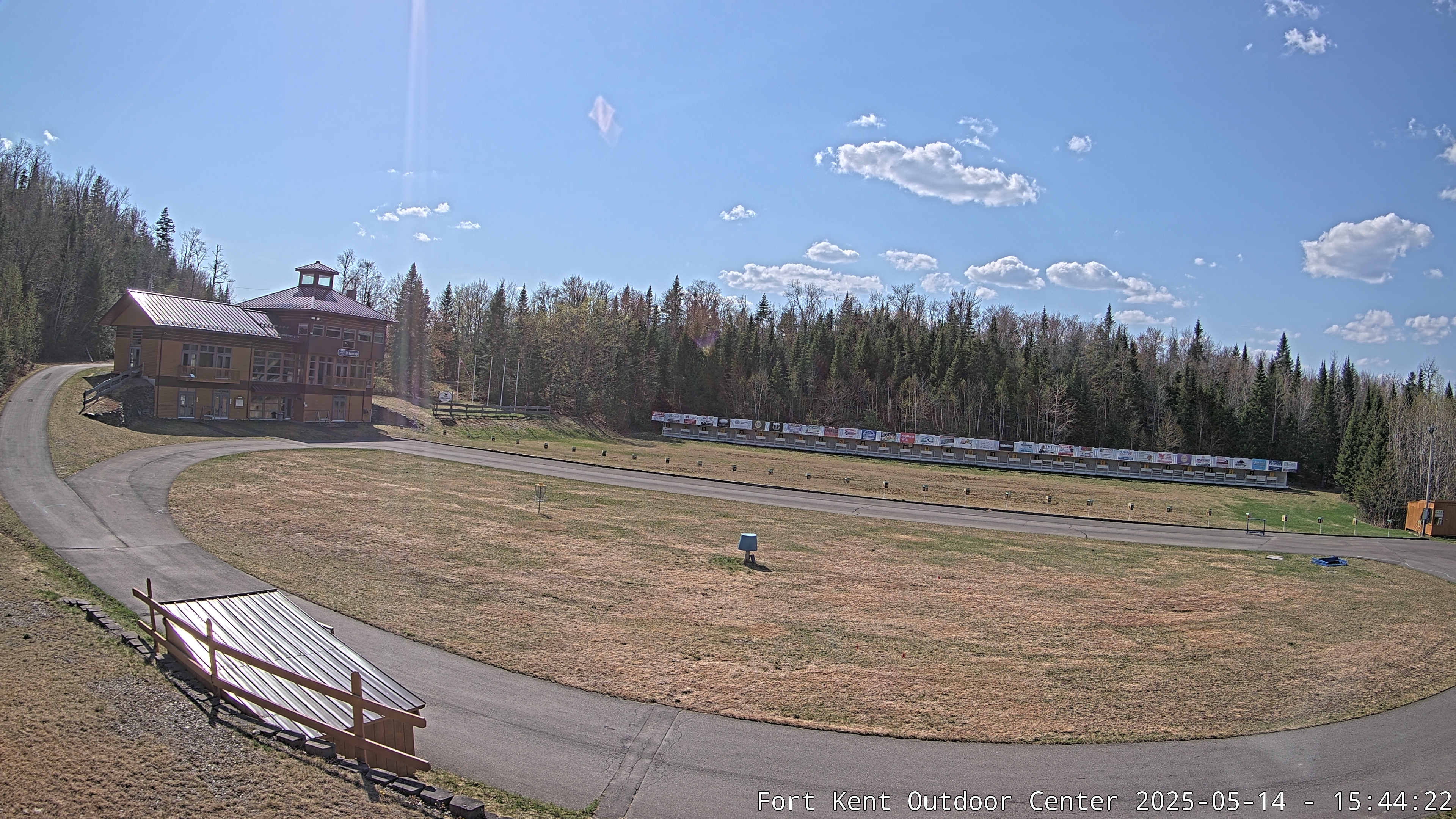
1 mi / 1.5 km SW of Apex Wx station in Fort Kent
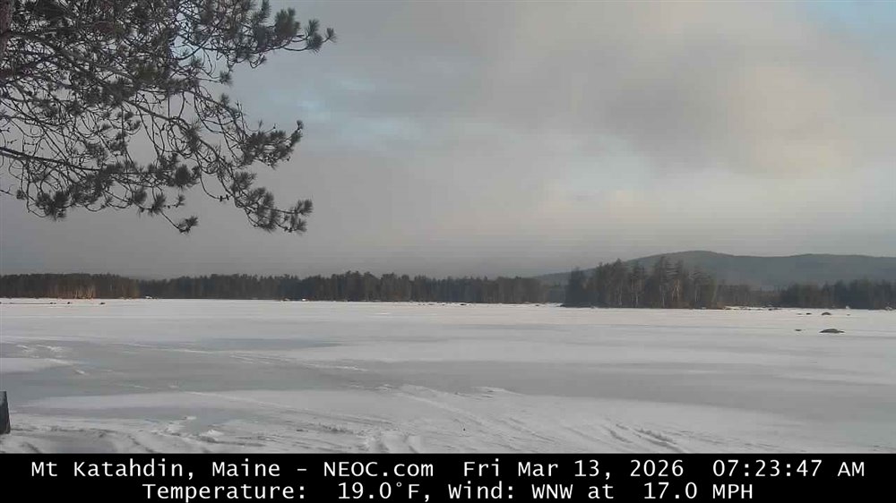
Mt. Katahdin
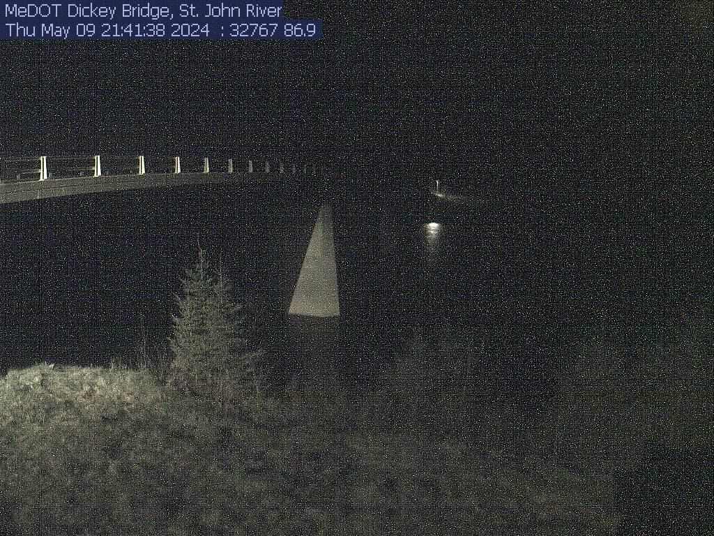
US Route 1 @ Van Buren, ME

March 1 to June 15 & Aug. 1 to Nov. 15
Apex Wx
Fort Kent & the Saint John Valley, Maine
Weather Information


Member APRSWXNET/CWOP & CWOP Programs
What is UTC Time?


Apex Wx is committed to no-hype forecasting based on meteorological science.
📊 Fort Kent Weather Almanac 📊 (Click to Collapse/Expand)
2022
☀️ Sun & Moon Information for Fort Kent, Maine 🌕
Last Quarter
New Moon
First Quarter
Full Moon
Loading phase details...
--:-- AM EDT tomorrow
--:-- AM EDT today
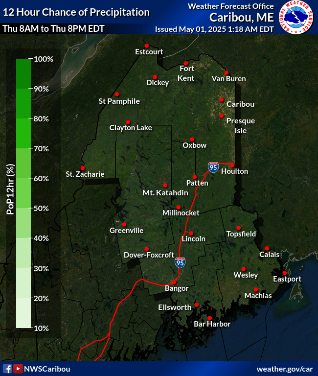
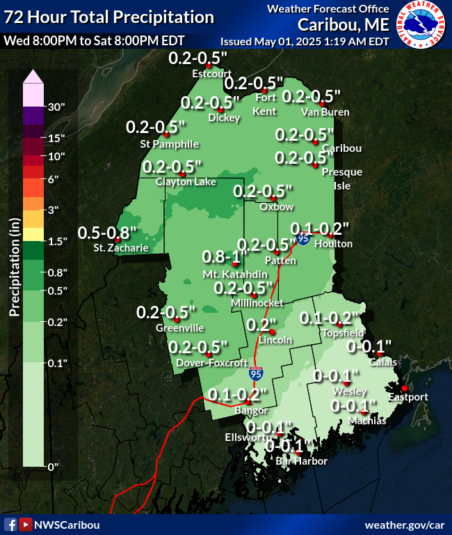
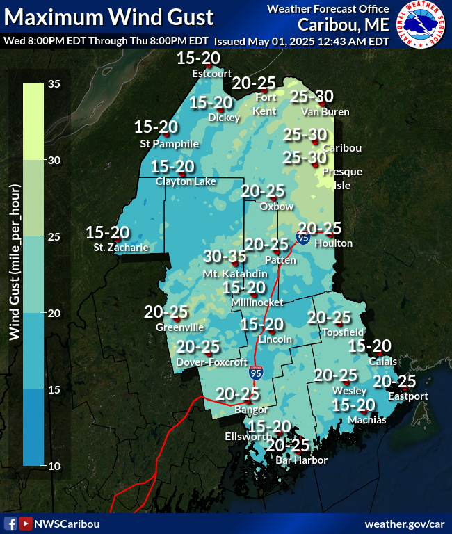
Scattered showers are expected to develop this afternoon across the Saint John Valley, with isolated thunderstorms also possible, which may produce locally heavier downpours. High temperatures will reach the lower to middle 80s. Light south winds will increase to around 5 to 10 mph, with gusts up to 20 mph. Rainfall totals less than 1/10-inch expected for most locations, though higher totals may occur in any storms.
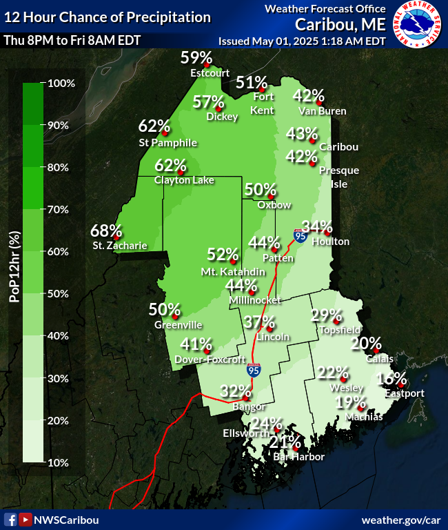
Showers will become more widespread tonight as the cold front approaches the Saint Lawrence River Valley. A few thunderstorms remain possible in the evening. Overnight lows will fall into the lower 60s, with light southeast winds around 5 mph. Rainfall amounts will generally range from around 1/10 to 1/4-inch, although locally higher totals are possible in heavier showers and thunderstorms. Areas of fog are expected to redevelop overnight, with the greatest likelihood of dense fog across Downeast locations.
On Monday, strengthening low pressure will track north of Maine, pulling the cold front across the state. Rain is expected across the entire Valley, with a slight chance of thunderstorms, though instability aloft will be limited. High temperatures will remain much cooler--in the lower to middle 70s. South winds around 10 mph will gust into the 20 to 25 mph range at times. Rainfall totals of around o1/2 to 3/4-inch are possible, although locally higher amounts could occur where heavier bands of rain develop.
Rain will gradually taper to scattered showers Monday night as the cold front moves east of the area. Skies will slowly begin to clear overnight, although patchy fog may redevelop late. Low temperatures will fall into the middle to upper 50s with light southwest winds around 5-6 mph in Fort Kent and vicinity.
By Tuesday, much drier air will move into the region as high pressure over the Great Lakes builds east. Any lingering morning showers will quickly end, giving way to mostly sunny skies. High temperatures will recover into the upper 70s, with west winds of 10 to 15 mph and gusts to around 20 to 25 mph. Tuesday night will be mostly clear and seasonably cool, with lows in the middle to upper 50s. Patchy late-night fog will once again be possible in some locations.
The high will begin to weaken on Thursday as an upper-level disturbance approaches from the west. Most of the day should remain partly to mostly sunny and warm, with afternoon highs again reaching the middle to upper 80s. A slight chance of showers will develop later in the afternoon as the atmosphere becomes somewhat more unsettled.
The unsettled pattern will continue Thursday night through Saturday as weak low pressure may develop in the vicinity of the region. While there will be opportunities for scattered showers and thunderstorms each day, confidence remains limited regarding the timing, location, and overall coverage of any rainfall. Current forecast guidance indicates that at least modest atmospheric instability may develop, which could support a few thunderstorms, but uncertainty remains with regards to storm coverage and intensity.
Temperatures will remain seasonably warm through the period, with daytime highs generally in the middle 80s and overnight lows in the lower 60s. Although many locations could remain dry for much of the time, a passing shower or thunderstorm is possible from Thursday afternoon through Saturday, especially during the afternoon and evening hours.
Maine / New Brunswick Regional Satellite

🇺🇸 US National Weather Outlook 🇺🇸
(Click to Collapse/Expand)
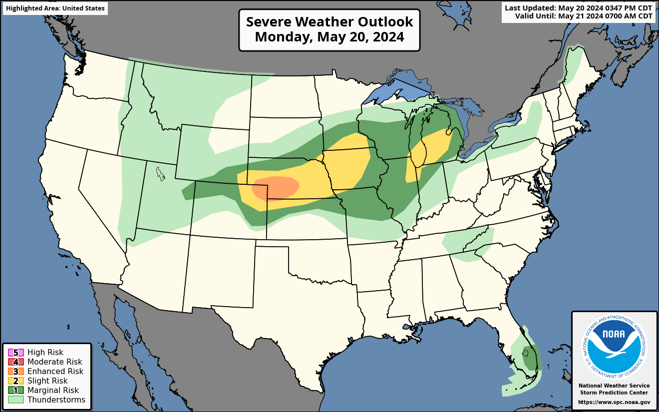
A heat wave over the Southwest will intensify this week, peaking and expanding into the Intermountain West and northern High Plains this weekend.through Tuesday. Meanwhile, a weather system will bring showers and thunderstorms across much of the eastern United States Slight risks of excessive rainfall are forecast on Sunday for parts of the Lower Great Lakes, Ohio Valley, Central Appalachians, North Carolina coast, and Florida Gulf Coast. On Monday, the threat shifts into the Northern Mid-Atlantic, New England, the Carolina coast, and eastern Florida Gulf Coast. Heavy rain could cause localized flash flooding, especially in cities, on roads, near small streams, and in low-lying areas. Meanwhile, the Southwest and Southern Rockies may experience locally heavy monsoon rainfall. A separate storm system will bring severe thunderstorms to parts of the Upper Midwest on Monday, with damaging winds, large hail, frequent lightning, and a few tornadoes possible.

Scattered strong thunderstorms are expected this afternoon and evening across parts of the Lower Great Lakes, Upper Ohio Valley, and the Middle and Southern Atlantic states. The main threat will be localized damaging wind gusts, although a brief tornado cannot be ruled out in parts of the Lower Great Lakes and Allegheny Plateau if storms become more organized. Heavy rainfall and frequent lightning are also possible. Thunderstorm development will depend on how much sunshine breaks through early cloud cover. Later tonight, storms may develop across parts of North Dakota as another weather system approaches. These storms could produce hail and gusty winds, but confidence in their coverage and intensity remains lower than in the eastern United States.
Learn more about Excessive Rainfall Risk
Heavy
Rain Threat Targets Florida,
the Northeast, and Coastal
North Carolina
Widespread showers and
thunderstorms are expected from
the Florida Gulf Coast through
the Mid-Atlantic and into the
Northeast on Sunday. A strong
weather system will draw deep
tropical moisture northward,
creating conditions for heavy
rainfall and localized flash
flooding. The greatest concern
is across the Florida Big Bend,
coastal North Carolina, and
areas from the eastern Great
Lakes into the central
Appalachians and Northeast,
where a Slight Risk of excessive
rainfall is in effect. Rainfall
rates of 1 to 3 inches per hour
and storm cells moving
repeatedly over the same
locations could produce several
inches of rain, especially on
already saturated ground.
Isolated flash flooding is also
possible in parts of the
Southwest where scattered
thunderstorms develop.

🔥Fire Weather Outlook🔥
Learn more about Fire Weather Outlooks
Critical fire weather conditions are expected today across parts of northern Utah, central and eastern Idaho, western and central Wyoming, and much of Montana as strong winds, very low humidity, and dry vegetation combine to increase wildfire danger. A dry cold front will bring sustained winds of 15 to 25 miles per hour, with gusts reaching 30 to 40 miles per hour and locally higher near the Rocky Mountains. Humidity levels will fall as low as 10 percent in some areas, allowing fires to spread rapidly. Elevated fire weather conditions will also extend into parts of eastern Washington, eastern Oregon, the Great Basin, and the northern Great Plains. Residents should avoid activities that could accidentally ignite wildfires.

National Weather Outlook information sources: Weather Prediction Center & Storm Prediction Center
🌤️ Weather Resources 🌤️
(Click
to Collapse/Expand)
🇺🇸 NOAA/National Weather Service Weather Information

NWS Caribou Weather
Information
NWS Caribou Weather
Information🌎 World Weather
World Temperature Extremes | US Temperature Extremes | Canadian Temperature Extremes | Europe Temperatures Extremes | Northern Hemisphere | Southern Hemisphere | Earth from Nullschool | Weather Around The World | CoolWx World Weather Extremes
APOD | SolarHam | Webb Image Galleries | Space.com | National Aeronautics and Space Administration (NASA) | Spaceflight Now | NASA's ISS Sighting Opportunities | Sky & Telescope's: This Week's Sky at a Glance | Space Weather | Stellarium Web Online Star Map | Heavens Above | Moon Times for Fort Kent, Maine | Fort Kent Sun & Moon Data
Apex Wx is a private weather information service unaffiliated with NOAA/NWS operated by Joseph Becker, PhD. Dr. Becker holds a certification in weather forecasting from Penn State University and is a trained NWS Storm Spotter.
Credits
- Sun/Moon data from US Naval Observatory with additional information from timeanddate.com.
- NOAA Warning Banner provided by WillyWeather.com.
- Until Dec. 2026, additional Archived Weather Data from Apex Wx is at the University of Utah's MesoWest
- Apex Wx logo by Joanna Becker ©2016 (Visit Bushi and Brush Arts Dojo)
The vast majority of weather apps are automated without human oversight and can miss critical, nuanced details during severe or changing weather. Do not rely on an app for the forecast. Instead, go to weather.gov for the foreca
Radar apps visualize precipitation intensity using color-coded echoes. However, updates are not instant, and even the most advanced composite radar mosaics can be delayed by 5 to 20 minutes by the time they reach your app.That delay means the weather you are viewing might already be miles away — or more intense than the image suggests.

US Visible/Infrared Satellite


US Snowfall Outlook


Northeast Wind Gust Outlook
Northeast Wave Height Outlook


St. John River at Dickey


