
NWS
Caribou Watches & Advisories

NE
Weather Chart

Regional
Radar from NWS Caribou

Today's High


Tonight's
Low

Tonight's
Wind Chill ("Feels Like")

Today's
Probability of Precipitation
Tonight's
Probability of Precipitation
3-Day
Precipitation Totals
Winter
Storm Severity Index (WSSI)

Snowfall
Outlook
Ice
Accumulation Outlook
3-Day
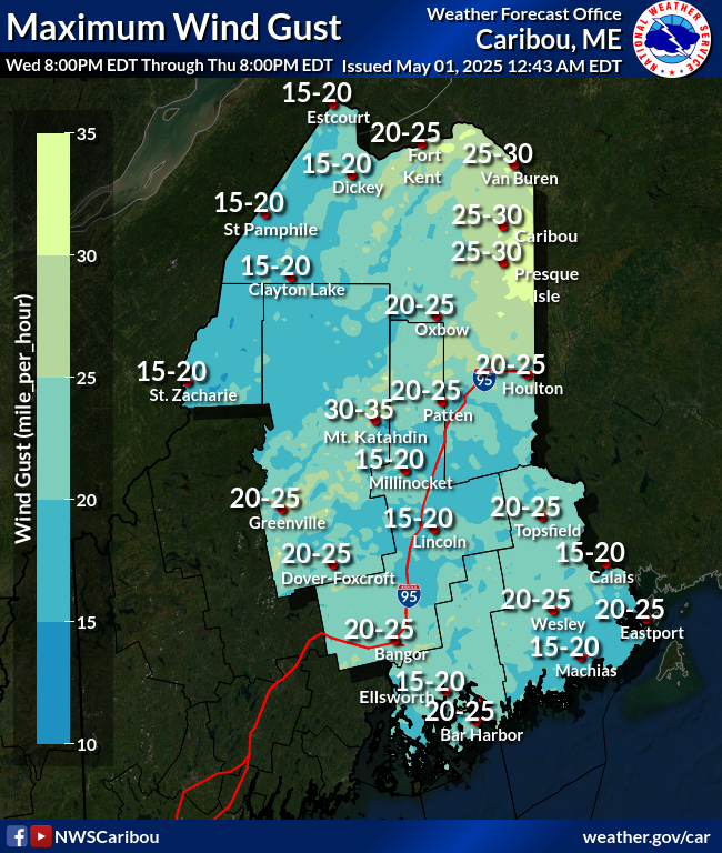
Maximum Wind Gust
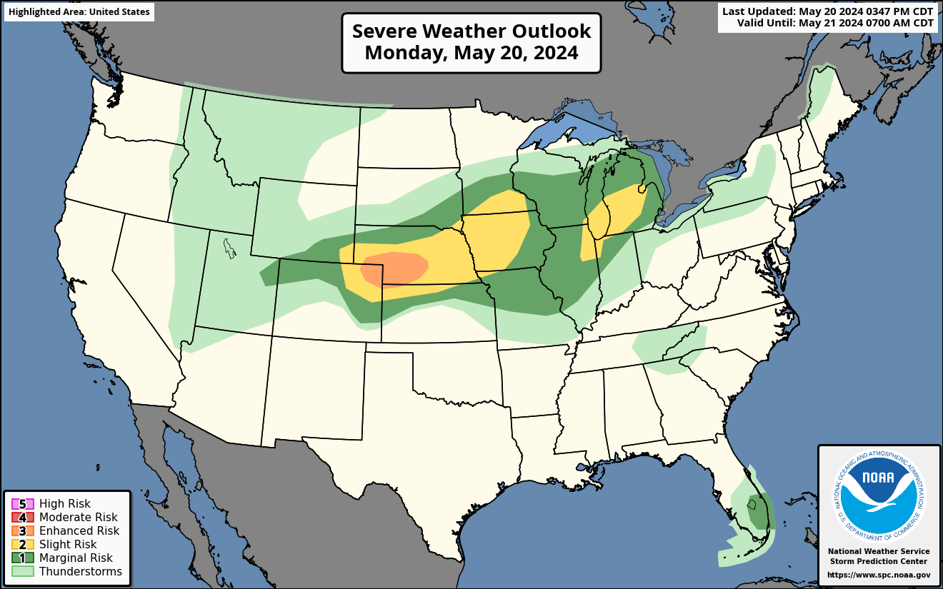
Today's Severe Weather
Outlook

Today's Tornado Outlook

Today's Severe Wind Outlook

Today's Severe Hail Outlook

Today's
Fire Weather Outlook


Apex Wx
Fort Kent & the Saint John Valley,
Maine
Weather Information


Weather
information for Fort Kent & the Saint John Valley since 2009
Member APRSWXNET/CWOP & CWOP Programs
Member APRSWXNET/CWOP & CWOP Programs
via Google Translate
Current Time (24-Hour)
EST -5 hours / EDT -4 hours from UTC
Many weather
graphic timestamps are in UTC / Z Time

Contributions
help support this weather information service.
📅 Fort Kent
Weather Almanac 📅
Non-metric
units unless otherwise indicated; times US Eastern
MesoWest
has live and archived Apex Wx data (Station EW0429 Fort Kent).
Wednesday, January 28
High: 14° at 2:22
pm | Low: -7° at 10:45 pm
Rain: 0.00" | Snow: 0.0"
Avg. Daily Wind: NNE at 1 mph | Daily
Maximum Gust: 18 mph at 12:09 pm
Data source: Davis Instruments Vantage Pro 2 Personal Weather Station | Rain gauge not heated in winter.
Data source: Davis Instruments Vantage Pro 2 Personal Weather Station | Rain gauge not heated in winter.
Thursday, January 29
Normal High: 19°
| Record High: 46° (1994)
Normal Low: -5° | Record Low: -34° (1971)
Normal Low: -5° | Record Low: -34° (1971)
Normal Daily
Precipitation: 0.07" | Record
Precipitation: 0.85" (1977)
Normal Daily Snow: 0.7" |
Record Snow: 12.0" (1977)
Source: NOAA
SC-ACIS NWS Caribou climate data collected since
1893
Precipitation 2026
Rainfall: 2.36" | normal
= 2.63" (-0.27")Snowfall
25-26: 55.2" | normal = 51.4" (+3.8")
Snowfall 24-25: 73.2" | normal = 99.3" (-26.1")
Snowfall 24-25: 73.2" | normal = 99.3" (-26.1")
❄️
Annual snowfall measured from
July 1 - June 30 ❄️
Data source: NOAA SC-ACIS NWS Caribou climate data collected since 1893
Data source: NOAA SC-ACIS NWS Caribou climate data collected since 1893
Loading
season...
Fort
Kent, Maine, USA — Sun & Moon Today
Loading
sunrise/sunset...
Moon
Phase: 🌔 Waxing Gibbous → 🌕 Full "Snow" Moon
5:09 pm Sun. 1 Feb 2026
experimental
The Week Ahead for Fort Kent & the Upper Saint John
Valley of Maine
7-Day Outlook: Thu. Jan. 29 -
Wed. Feb. 4
Updated January 29 at 7:55 am EST
Updated January 29 at 7:55 am EST
Today - Saturday
Light snow is expected across northern Maine later today and
tonight. A slow-moving low near Labrador will pull cool, moist air
back into the region from the northeast. This will cause snow to
gradually spread into the Valley this afternoon, continuing through
the night and into early Friday morning. By Friday morning, snowfall
totals should generally range from 1 to 3 inches. Snow will become
lighter and more scattered Friday afternoon, turning into snow
showers before ending.
Snow will begin to overspread the area later this afternoon as
moisture increases from the northeast. Daytime temperatures will
remain cold, topping out near 10 degrees, with dangerous wind chills
as low as -25 to -30 at times. Snowfall this afternoon will be
light, with generally less than an inch of accumulation expected
before sunset.
Snow becomes more widespread and steadier this evening and overnight as the system continues to influence the region. Accumulations tonight are expected to range from 1 to 2 inches. Overnight lows will fall to the 0 to 5 above range, with wind chills remaining below zero.
Snow will likely continue into Friday morning, then gradually taper to scattered snow showers late in the morning into early afternoon. Additional accumulation on Friday will be light, generally less than one-half inch. Temperatures will recover slightly into the 10-15 above range, though brisk northwest winds will keep wind chills below zero.
High pressure builds in Friday night through Saturday, bringing clearing skies and dry conditions. Overnight lows will dip to around 0 or just below, with highs on Saturday reaching the mid-10s under mostly sunny skies. Mostly clear skies will allow low temperatures to fall to 0 to -5 Saturday night in Fort Kent and vicinity.
Sunday - Wednesday
Low pressure off the Southeast US will develop as cold high
pressure moves into the central US. The low will develop into a
Nor'easter and move up the East Coast towards the Northeast US.
The American GFS and the Canadian CMC keep most of the system's
precipitation offshore. However, while these models are tending
to keep the system offshore, the European ECMWF is tracking the
system closer to the coast, which may result in more significant
impacts to Downeast Maine as the weekend progresses.
If the storm comes closer to the coast, coastal areas could
see heavy snow, strong winds, and near-blizzard conditions. Some
forecast models continue to suggest the potential for
significant snow and wind along the coast, while others show
much weaker impacts or even a near miss. Recent information
slightly favors the lower-impact scenario at this time. Any
variations in the system's track will affect its impact on
Maine, of course.
For the Saint John Valley, based on current data, quiet
weather is expected to continue through the early part of the
week as high pressure remains in control. On Sunday, partly
sunny skies and light north winds will keep temperatures on the
cold side, with highs near 20 degrees. Clouds will increase
Sunday night, but conditions remain dry with lows 5 to 10 above.
Mostly sunny and dry conditions return on Monday and Tuesday as the high pressure continues to dominate the area's weather. Daytime temperatures will slowly moderate into the lower to mid-20s, while overnight lows fall into the 5 to 10 above range Monday night and 0 to 5 above Tuesday night. Winds will stay light through this period, providing relatively calm winter weather.
By Wednesday, a bit more cloud cover is expected, but dry conditions continue. Temperatures will cool slightly, with highs near 20 degrees. Mostly cloudy skies with lows around 0°F are expected Wednesday night. Overall, the period looks relatively tranquil with no significant weather events expected.
🌤️ Daily Weather for Fort
Kent & Vicinity 🌤️
Updated every 3-6 hours from NWS
Caribou
Maine / New Brunswick Regional Satellite

Credit: College of
DuPage / NOAA GOES-19 Imagery (visible--day;
night--infrared)
US
National Weather Outlook
Updated
January 29, 2026
Today -
Saturday
A major winter storm is expected to affect much of
the eastern US from Thursday into Saturday. The
storm will develop over the southern Plains, move
along the Gulf Coast, and then strengthen rapidly
as it tracks up the Southeast Coast. Snow and rain
will spread from the Mississippi Valley into the
Ohio and Tennessee Valleys, then into the southern
Mid-Atlantic by Friday night and Saturday. Very
strong winds and heavy snow may create
near-blizzard conditions in parts of coastal North
Carolina and southeastern Virginia, along with
coastal flooding. Elsewhere, lake-effect snow will
impact the Great Lakes, while snow falls across
the Plains and rain and mountain snow affect the
Pacific Northwest.Sunday
- Wednesday
A very active and
cold weather pattern is expected from Sunday
into midweek. A major coastal winter storm
will move up the East Coast over the weekend,
rapidly strengthening offshore. Heavy snow,
strong winds, large waves, and coastal
flooding are most likely from the Carolinas
northward through the Mid-Atlantic and into
New England, with especially unusual impacts
possible along the Carolina coast. Behind the
storm, repeated surges of Arctic air will keep
much of the central and eastern US dangerously
cold, with some record temperatures possible.
Additional light snow systems may affect the
Midwest and Great Lakes. Farther west, periods
of rain and mountain snow will continue in the
Pacific Northwest.
⛈️Thunderstorm/Severe
Weather Outlook⛈️
Thursday:
A cool, stable weather pattern is in
place today and tonight, and thunderstorms are
not expected. A large area of low pressure
high in the atmosphere over central Canada is
keeping cold, dry air spread across much of
the central and eastern United States. Several
weak disturbances are moving through this
pattern, but they will only reinforce the cool
and quiet conditions. Out West, a building
ridge of high pressure will bring generally
calm weather, while a couple of weak systems
pass through the Pacific Northwest. These
systems may bring periods of rain showers, but
the atmosphere will not be unstable enough to
support lightning or thunder.
Friday: Thunderstorms
are not expected from Friday through Friday
night. A large weather system will strengthen
over the eastern United States as several
smaller disturbances combine, while high
pressure remains in control across the West.
This setup will help a weak area of low
pressure form near Florida and the eastern
Gulf, then rapidly strengthen offshore late
Friday into early Saturday. Although a brief
increase in moisture may occur ahead of a cold
front across southern Florida and the Keys, it
will be short-lived and limited. The
atmosphere is not expected to become unstable
enough to support thunderstorm development
during this time.
Saturday:
Thunderstorms are not expected on
Saturday. A strong and unusually large weather
system will dominate the eastern United
States, with a powerful storm strengthening as
it moves north along the East Coast. Behind
this storm, colder and drier air will spread
across much of the country as high pressure
builds in from the west. This pattern will
keep moisture limited and reinforce an Arctic
air mass across most areas. As a result,
conditions will not support thunderstorm
development over land, with any thunderstorm
activity remaining confined to offshore waters
well away from the coast.
Sunday -
Thursday: Severe weather is not
expected through the extended forecast period.
A large, slow-moving low pressure system over
the eastern US will move offshore this
weekend, followed by several smaller
disturbances. Northwesterly winds aloft and
the passage of cold fronts early next week
will keep temperatures cool across the central
US and limit the return of warm, moist air.
This will largely prevent the development of
thunderstorms inland. While a few storms could
occur along the Gulf Coast later next week if
a stronger system moves through, overall the
risk of thunderstorms or severe weather
remains very low for most areas over the
coming week.
National Outlook
Sources: Weather
Prediction Center &
Storm Prediction Center
Today's
US
Forecast Chart

🌪️Today's US Severe Weather / Thunderstorm Outlook
Learn
more about Severe
Thunderstorm Outlooks
Today's
US High Temperature Outlook
Tonight's
US Low Temperature Outlook
8-14
Day Temperature Outlook

8-14
Day Precipitation Outlook

Bird
Migration Forecast Map

Migration
Forecasts Updated March 1 to June
15 & Aug. 1 to Nov. 15
🌤️Weather Resources🌤️
US
National Weather Service
| Weather
Prediction Center | Short
Range Forecast Discussion | Medium
Range Forecast Discussion | Extended
Forecast Discussion |
Storm Predication Center | Climate
Prediction Center | Tsunami
Warning System | National
High/Low Temperature

NWS Caribou Weather Information
NWS Caribou Weather InformationME
Zone 001 Forecast for Northwest
Aroostook | Winter
Weather Forecasts |
Area Forecast Discussion | NWS
Caribou Regional Climate Data
| NWS
Caribou YouTube Channel | Recreation
Forecast for Northern &
Eastern Maine | NWS
Gray/Portland Office
| Regional
Weather Roundup | Current
Observations (Maps)
⛰️ Other Regional
Resources
Maine
DOT Cams | New
England Road Conditions |
Maine
Wildfire Report | Mount
Washington, NH Observatory
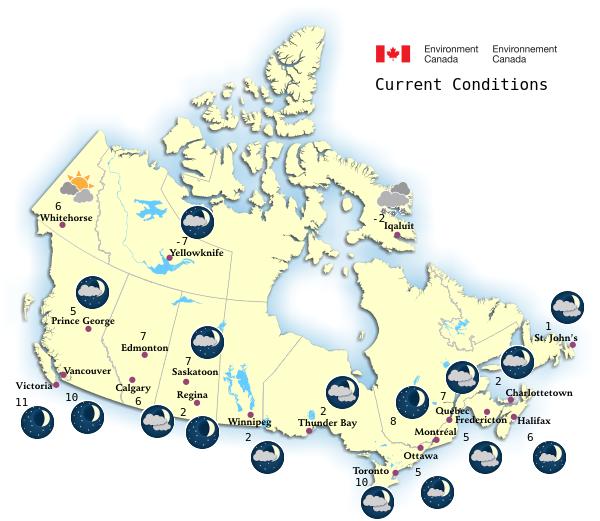
🇨🇦 Environment
Canadian Weather Information
🌎 World Weather
World Temperature Extremes | US Temperature Extremes | Canadian Temperature Extremes | Europe Temperatures Extremes | Northern Hemisphere | Southern Hemisphere | Earth from Nullschool | Weather Around The World
🛠️ Conversion Tools
APOD | SolarHam | Webb Image Galleries | Space.com | National Aeronautics and Space Administration (NASA) | Spaceflight Now | NASA's ISS Sighting Opportunities | Sky & Telescope's: This Week's Sky at a Glance | Space Weather
🔭
Astronomy Links
APOD | SolarHam | Webb Image Galleries | Space.com | National Aeronautics and Space Administration (NASA) | Spaceflight Now | NASA's ISS Sighting Opportunities | Sky & Telescope's: This Week's Sky at a Glance | Space Weather
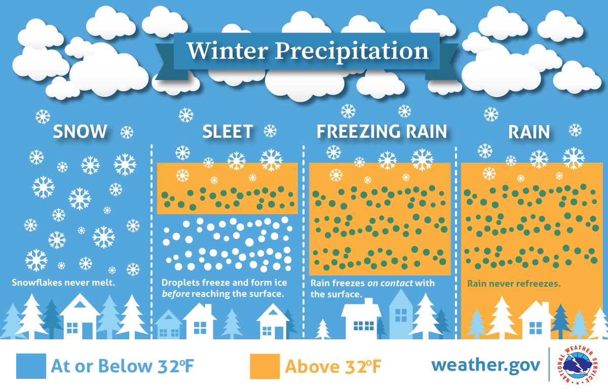
Learn
more about winter precipitation
types
⚠️ Weather Notice: This
information is compiled by Joseph Becker / Apex Wx based on available
computer models and data and may not reflect current conditions or
later forecast updates. Always visit NWS
Caribou at https://www.weather.gov/car/ for the
latest official watches, warnings, and advisories for northern Maine.
Apex Wx is a private weather information service unaffiliated with NOAA/NWS operated by Joseph Becker, PhD. Dr. Becker holds a certification in weather forecasting from Penn State University and is a trained NWS Storm Spotter.
Apex Wx is a private weather information service unaffiliated with NOAA/NWS operated by Joseph Becker, PhD. Dr. Becker holds a certification in weather forecasting from Penn State University and is a trained NWS Storm Spotter.
Forecast outlooks written by Dr. Becker
are usually posted between 7 - 9 am M-F / 8 -10 am weekends &
holidays.
Additional Archived Weather Data from
Apex Wx is at the University of Utah's MesoWest
Apex Wx logo by Joanna Becker ©2016
(Visit Bushi and Brush
Arts Dojo)
US
Surface Weather Chart

Weather
Underground
US Visible/Infrared Satellite

College of
DuPage NEXLAB
US Weather
Radar

Weather
Underground
US Advisories, Watches, & Warnings

Today's
Excessive Rainfall Outlook

Today's US Fire Weather Outlook

Yesterday's Storm Reports

2-Day Tropical Atlantic
Outlook

Graphics update June - November
7-Day Tropical Atlantic Outlook

Graphics
update June - November

Northeast
Precipitation Outlook


Northeast Snowfall Outlook
Northeast Ice Accumulation
Outlook

Northeast Wind Gust Outlook
Northeast Wave Height Outlook
Maine
Drought Monitor

Saint John
River at Fort Kent

Ice in winter may affect gauge
measurement.
Fish River
at Fort Kent

Ice in winter may affect gauge
measurement.
Allagash
River above Allagash

Ice in winter may affect gauge
measurement.
St. John River at Dickey

Ice in winter may affect gauge
measurement.
Environment
Canada Weather Map
Temperature
in Celsius

